
Advertisement

Angus Council
Map of the Angus Council Area
The area shaded blue on the map represents the extent of Angus Council. The map pin represents the location of the council offices.
Angus Council has a population of 110,300.
Angus Council is within the ceremonial county of Angus
click to enlarge

Download Print Quality PDF of Councils in Angus
Councils Neighbouring Angus Council
Wards within Angus Council
click to enlarge
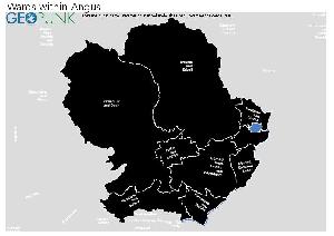
- Kirriemuir and Dean
- Brechin and Edzell
- Forfar and District
- Monifieth and Sidlaw
- Carnoustie and District
- Arbroath West, Letham and Friockheim
- Arbroath East and Lunan
- Montrose and District
Download Print Quality PDF of Wards in Angus Council
Angus Council Contact Details
| Website | http://www.angus.gov.uk |
| Contact Us Page | http://www.angus.gov.uk/contact/default.html |
| Address | Angus House |
| Orchardbank Business Park | |
| Town | Forfar |
| County | Angus |
| Postcode | DD8 1AX |
| Telephone Number Description | Accessline |
| Telephone Number | 08452 777 778 |
| Fax Number | 01307 466 183 |
| Main Contact Email | accessline@angus.gov.uk |
| Opening Hours | Monday to Friday 8.00 am to 6.00 pm (accessline) |
Details for Angus Council
| Local Authority Name | Angus Council |
| SNAC Code | 00QC |
| Postcode | DD8 1AX |
| Latitude | 56.6351746266 |
| Longitude | -2.9211292665 |
| Country | Scotland |
| NHS Health Authority | Tayside |
| Parliamentary Constituency | Angus |
| European Electoral Region | Scotland |
| Primary Care Trust | Angus Community Health Partnership |
| Region | |
| Admin County | |
| ONS Code | S12000041 |
Political Make Up of Angus Council
2022 Election Results for Angus Council
| Council Seats up for Election | All |
|---|---|
| Scottish National Party | 13 |
| Labour | 1 |
| Liberal Democrats | 0 |
| Green Party | 0 |
| Conservatives | 7 |
| Others | 7 |
| Vacant Seats | 0 |