
Advertisement
Shropshire Council
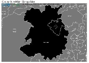
Map of the Shropshire Council Area
The area shaded blue on the map represents the extent of Shropshire Council. The map pin represents the location of the council offices.
Waste Recycling Performance
44 (12.79%) of local authorities perform better than Shropshire Council.
299 (86.92%) of local authorities perform worse than Shropshire Council.
Shropshire Council has a population of 292,800.
Shropshire Council is within the ceremonial county of Shropshire
click to enlarge
Download Print Quality PDF of Councils in Shropshire
Councils Neighbouring Shropshire Council
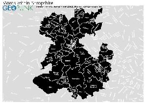
Wards within Shropshire Council
click to enlarge
- Quarry and Coton Hill
- Radbrook
- St Martin's
- Severn Valley
- Shawbury
- Shifnal North
- Shifnal South and Cosford
- Sundorne
- Tern
- Abbey
- Albrighton
- Alveley and Claverley
- Bagley
- Battlefield
- Bayston Hill, Column and Sutton
- Belle Vue
- Bishop's Castle
- Bowbrook
- Bridgnorth East and Astley Abbotts
- Bridgnorth West and Tasley
- Broseley
- Brown Clee
- Burnell
- Castlefields and Ditherington
- Cheswardine
- Chirbury and Worthen
- Church Stretton and Craven Arms
- Clee
- Cleobury Mortimer
- Clun
- Copthorne
- Corvedale
- Ellesmere Urban
- Harlescott
- Highley
- Hodnet
- Llanymynech
- Longden
- Loton
- Ludlow East
- Ludlow North
- Ludlow South
- Market Drayton East
- Market Drayton West
- Meole
- Rea Valley
- Monkmoor
- Much Wenlock
- Porthill
- Prees
- The Meres
- Underdale
- Wem
- Whitchurch North
- Whitchurch South
- Worfield
- Gobowen, Selattyn and Weston Rhyn
- Oswestry East
- Oswestry South
- Oswestry West
- Ruyton and Baschurch
- St Oswald
- Whittington
Download Print Quality PDF of Wards in Shropshire Council
Shropshire Council Contact Details
| Website | http://www.shropshire.gov.uk/ |
| Contact Us Page | http://shropshire.gov.uk/customer-service/how-to-contact-us/ |
| Address | Shropshire Council |
| Shirehall, Abbey Foregate | |
| Town | Shrewsbury |
| County | Shropshire |
| Postcode | SY2 6ND |
| Telephone Number Description | General enquiries |
| Telephone Number | 0345 678 9000 |
| Telephone Number Description | Out of hours emergency |
| Telephone Number | 0845 678 9040 |
| Fax Number | 01743 252 827 |
| Main Contact Email | customer.service@shropshire.gov.uk |
Details for Shropshire Council
| Local Authority Name | Shropshire Council |
| SNAC Code | 00GG |
| Postcode | SY2 6ND |
| Latitude | 52.7049955886 |
| Longitude | -2.73177901996 |
| Country | England |
| NHS Health Authority | West Midlands |
| Parliamentary Constituency | Shrewsbury and Atcham |
| European Electoral Region | West Midlands |
| Primary Care Trust | Shropshire County |
| Region | West Midlands |
| Admin County | |
| ONS Code | E06000051 |
Waste and Recycling Rates for Shropshire Council 2017-18
Waste Recycling Performance
44 (12.79%) of local authorities perform better than Shropshire Council.
299 (86.92%) of local authorities perform worse than Shropshire Council.

| Authority Type | Unitary |
|---|---|
| Waste per household KG | 506.5 |
| Percentage of household waste sent for reuse, recycling or composting | 54.10% |
| Collected household waste per person (kg) | 486.3 |
Employee Headcount for Shropshire Council
FTE = Full Time Equivalent
| Region | West Midlands |
|---|---|
| Total Headcount | 6363 |
| Total FTE | 4553 |
| Male Full Time | 683 |
| Female Full Time | 1593 |
| Male Part Time | 465 |
| Female Part Time | 3622 |
| Permanent | 5415 |
| Temporary/Casual | 948 |
| Male | 1148 |
| Female | 5215 |
| Full-time | 2276 |
| Part-Time | 4087 |
| Male Full Time perm | 577 |
| Female Full Time perm | 1369 |
| Perm Male | 961 |
| Perm Female | 4454 |
| Perm Full-time | 1946 |
| Perm Part-time | 3469 |
| Male total FTE perm | 835 |
| Female total FTE perm | 3056 |
| Male Full Time temp | 106 |
| Female Full Time temp | 224 |
| Temp Male | 187 |
| Temp Female | 761 |
| Temp Full-time | 330 |
| Temp Part-time | 618 |
| Male total FTE temp | 160 |
| Female total FTE temp | 502 |